From the January 2016 issue of GCM magazine:
Water use and conservation, Part 2: Region by region
An in-depth look at the regional results from GCSAA’s water survey provides superintendents some perspective on water use in their region.
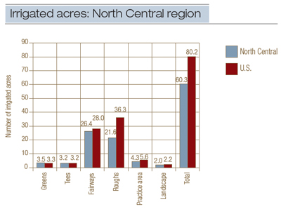
Figure 1. Median number of irrigated acres for an 18-hole golf course in the North Central region vs. the U.S., 2013.
Wendy Gelernter, Ph.D., and Larry Stowell, Ph.D.
Read this story in GCM's digital edition »
The December 2015 issue of Golf Course Management documented the U.S. golf industry’s impressive progress in water conservation. But there’s more to the story than just national trends. In this article, we examine each of the country’s seven agronomic regions in-depth, looking for answers to the following questions:
- What factors affect water use? Are they the same in each region of the country?
- In particular, what role does climate play in water use?
- Which regions were most successful in reducing water use in the past eight years? Why?
By answering these questions, we hope to provide superintendents with a framework through which they can evaluate their current water use patterns, as well as suggestions for how further progress in water use and conservation practices can occur in the future.
North Central region
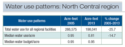
Table 1. Water use patterns in 2005 vs. 2013 in the North Central region.
From 2005 to 2013, water use across this region decreased by 25.7% (Table 1). Adoption of conservation practices resulted in approximately 85% of the decline in water use. A large decrease in the number of regional golf facilities (from 4,127 to 3,925) contributed approximately 15% to the decline in water use.
The region’s moderate temperatures, adequate rainfall and five- to seven-month growing season allow facilities to irrigate fewer acres, with less water and for a smaller portion of the year compared with those in warmer, more arid climates. Roughs are the feature most likely not to be irrigated (Figure 1).
Climate
- Average temperatures in the North Central region are some of the coolest in the U.S. and have a relatively small range, from a low of 37.6 F to a high of 53.7 F, depending on location.
- Rainfall is moderate, with average levels ranging from 1.5 feet to 3.9 feet per year, depending on location.
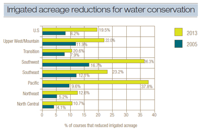
Figure 2. Trends in the use of irrigated acreage reductions for water conservation. There was a large increase in the use of this conservation measure in all regions.
Conservation practices
- In 2013, the percentage of golf courses using less water per acre than forecast by their water budgets (Table 1) had increased, indicating that water conservation efforts had a positive effect.
- The most common conservation practices were, in order of popularity, using wetting agents, hand watering, keeping turf drier than in the past, adjusting fertilizer practices, and increasing no-mow acres.
- In 2013, 10.7% of North Central golf courses had reduced the number of irrigated acres. This is more than double the 4.1% from 2005 (Figure 2).
Water costs
- In 2013, water costs for an 18-hole golf course were the lowest among the nation’s seven agronomic regions. Twenty-five percent of all 18-hole courses paid $505 or less per year for water, 50% paid $1,734 or less, and 75% paid $5,950 or less per year.
- In 2013, water cost per acre-foot had decreased to $40, compared with $67 in 2005.
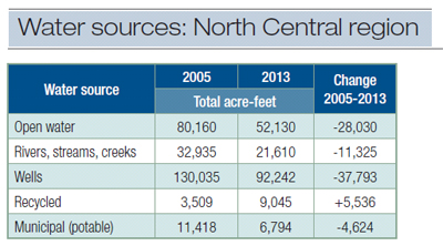
Table 2. Water sources used in the North Central region, 2005 vs. 2013.
Water sources
- As in 2005, well water was the most commonly used water source in 2013 (Table 2).
- Between 2005 and 2013, use of all water sources decreased, with the exception of recycled water.
- Increased use of recycled water contributed to the 40% reduction in the use of potable water.
Northeast region
From 2005 to 2013, water use across this region decreased by 19.4% (Table 3). Adoption of conservation practices resulted in approximately 89% of the decline in water use. A decrease in the number of regional golf facilities (from 2,746 to 2,677) contributed approximately 11% to the decline in water use.
The region’s moderate temperatures, adequate rainfall and a six- to seven-month growing season allow facilities to irrigate fewer acres, with less water and for a smaller portion of the year compared with those in warmer, more arid climates. Roughs are the feature most likely not to be irrigated (Figure 3).
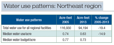
Table 3. Water use patterns in 2005 vs. 2013 in the Northeast region.
Climate
- Average temperatures in the Northeast region are cool and have a relatively small range, from a low of 38.4 F to a high of 56.2 F, depending on location.
- Rainfall is moderate to substantial, with average levels ranging from 2.7 feet to 4.6 feet per year, depending on location.
Conservation practices
- In 2013, the percentage of northeastern golf courses using less water per acre than forecast by their water budgets (Table 3) had increased, indicating that water conservation efforts had a positive effect.
- The most common conservation practices were, in order of popularity, using wetting agents, keeping turf drier than in the past, hand watering, adjusting fertilizer practices, and increasing no-mow acreage.
- In 2013, 12.6% of golf courses in the Northeast had reduced the number of irrigated acres. This is more than double the 5.2% from 2005 (Figure 2).
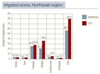
Figure 3. Median number of irrigated acres for an 18-hole golf course in the Northeast region vs. the U.S., 2013.
Water costs
- Water costs for an 18-hole golf course were the second lowest among the nation’s seven agronomic regions. Twenty-five percent of all 18-hole courses paid $2,200 or less per year for water, 50% paid $7,200 or less, and 75% paid $23,625 or less per year.
- In 2013, water cost per acre-foot had risen to $667, compared with $245 in 2005.
Water sources
- Open water (lakes and ponds) and well water were the most commonly used water sources in 2013 (Table 4).
- Between 2005 and 2013, use of all water sources decreased, with the exception of recycled water.
- Increased use of recycled water contributed to the 56% reduction in the use of potable water.
Pacific region
From 2005 to 2013, water use across this region stayed relatively flat, with a decrease of less than 1% (Table 5). Factors that influenced this trend include:
- The number of golf facilities decreased from 655 to 638 — only 2.6% since 2005. As a result, water savings due to reductions in the number of facilities were minimal.
- Although some areas of the Pacific region suffered from drought in the past several years, other areas did not. As a result, drought had minimal impact on the regional trends in water use between 2005 and 2013.
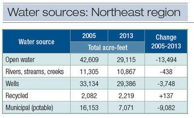
Table 4. Water sources used in the Northeast region.
Climate
- The Pacific region covers the most climatically diverse area of the U.S., ranging from the hot Central Valley of California to the long winters of Alaska to the cool redwood forests of Oregon.
- Because of climate diversity within the Pacific region, golf courses there exhibit a large range of water use volumes (Figure 4, bottom of page).
- Average temperatures have a large range, from a low of 34.0 F to a high of 62.1 F, depending on location.
- Precipitation varies significantly depending on location, from only 0.8 foot per year to a high of 14.2 feet per year.
- The number of irrigated acres is very close to the national median value (Figure 5).
Conservation practices
- In 2013, the majority of golf courses used less water per acre than forecast by their water budgets (Table 5).
- The most common water conservation practices, listed in order of popularity, included using wetting agents, hand watering, keeping turf drier than in the past, increasing no-mow acres, using irrigation scheduling techniques, and mulching landscape beds.
- In 2013, 37.8% of Pacific region golf courses had reduced the number of irrigated acres. This is more than three times the 9.6% from 2005 (Figure 2).
Water costs
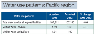
Table 5. Water use patterns in 2005 vs. 2013 in the Pacific region.
- In 2013, water costs for an 18-hole golf course were the highest among the nation’s seven agronomic regions. Twenty-five percent of all 18-hole courses paid $69,350 or less per year for water, 50% paid $159,730 or less, and 75% paid $367,915 or less per year.
- In 2013, water cost per acre-foot had more than doubled to $1,340, compared with $507 per acre-foot in 2005.
Water sources
- As in 2005, well water was the most commonly used water source in 2013 (Table 6).
- Between 2005 and 2013, use of all water sources decreased, with the exception of recycled water and municipal (potable) water.
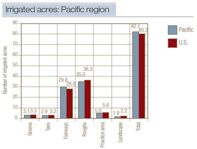
Figure 5. Median number of irrigated acres for an 18-hole golf course in the Pacific region vs. the U.S., 2013.
Southeast region
From 2005 to 2013, water use across this region was reduced by 39.3%, which was the greatest water use reduction in the country (Table 7). Factors involved in this decrease in water use include:
- Implementation of conservation practices, which contributed to approximately 90% of the water savings.
- The large decrease in the number of golf facilities since 2005 (from 3,250 to 3,046), which contributed to approximately 10% of the water savings.
- Although some areas experienced record rainfall in 2013, other areas in the region received less than average accumulations. As a result, weather had minimal impact on the trends in water use between 2005 and 2013.
The Southeast region used 29% of the total water used by the golf industry in 2013, making this region and the Southwest the highest water-using regions in the country. Reasons for this include the year-round growing season, high temperatures and high number of irrigated acres (Figure 6).
Climate
- Average temperatures in the Southeast region are the warmest in the country and range very widely, from 45.8 F all the way to 77.8 F, depending on location.
- Rainfall varies from moderate (1.7 feet/year) to heavy (5.7 feet/year), depending on location.
- Because of climate diversity within the Southeast region, golf courses there exhibit a large range of water use volumes (Figure 4).
- Turf is actively growing 12 months of the year in most locations in this region.
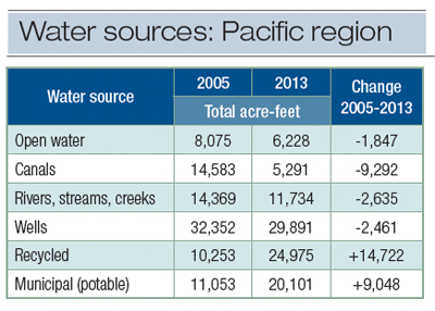
Table 6. Water sources used in the Pacific region.
Conservation practices
- In 2013, approximately 50% of all golf courses used less water per acre than forecast by their water budgets (Table 7).
- The most common water conservation practices, listed in order of popularity, were using wetting agents, keeping turf drier than in the past, hand watering, mulching landscape beds, and adjusting fertilizer practices.
- In 2013, 23.2% of southeastern golf courses had reduced the number of irrigated acres. This is almost double the 12.1% from 2005 (Figure 2).
Water costs
- Water costs for an 18-hole golf course were relatively low. Twenty-five percent of all 18-hole courses paid $11,915 or less per year for water, 50% paid $28,900 or less, and 75% paid $69,900 or less per year.
- In 2013, water cost per acre-foot had increased to $226, compared with $159 in 2005.
Water sources
- While open water (lakes and ponds) was the most heavily used water source in 2005, recycled water was the most heavily used source in 2013 (Table 8).
- Between 2005 and 2013, use of all water sources decreased, with the exception of recycled water.
- The Southeast is second only to the Southwest in the volume of recycled water that is used.
- Increased use of recycled water contributed to the 39.5% reduction in the use of potable water.
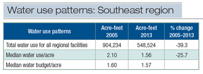
Table 7. Water use patterns in 2005 vs. 2013 in the Southeast region.
Southwest region
Unlike regions in the northern U.S., the Southwest region did not see a decrease in overall regional water use, water use per facility or acre-feet/acre between 2005 and 2013 (Table 9). One reason for this trend is that the number of golf facilities decreased by only 1.9% (from 1,224 to 1,201) since 2005. As a result, water savings from reductions in irrigated acreage was minimal.
While several areas of the Southwest have suffered from drought in the past several years, other areas have not. As a result, weather had minimal impact on the trends in water use from 2005 to 2013.
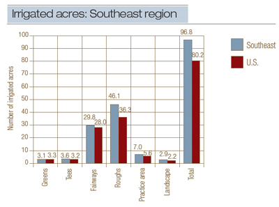
Figure 6. Median number of irrigated acres for an 18-hole golf course in the Southeast region vs. the U.S., 2013.
The Southwest region used 29% of the total water used by the golf industry in 2013, making this region and the Southeast the highest water-using regions in the country. Reasons for this include the year-round growing season, high temperatures, low rainfall and high number of irrigated acres (Figure 7).
Climate
- Like the Pacific region, the Southwest region encompasses many highly varied climates that range from the cool and dry Southern California coast to the tropical climate of Hawaii to the Sonoran Desert.
- Average temperatures in the Southwest region are the second highest in the country and range very widely, from 40.5 F to 75.2 F, depending on locations.
- Rainfall varies widely from 0.3 foot/year to 10.2 feet/year, depending on location.
- Because of climate diversity within the Pacific region, golf courses there exhibit a large range of water use volumes (Figure 4).
- Turf is actively growing 12 months of the year in most locations in this region.
Conservation practices
- Use of all water conservation practices increased since 2005, except for use of irrigation scheduling, which remained in use by approximately 57% of all respondents.
- The most common water conservation practices, listed in order of popularity, were using wetting agents, hand watering, keeping turf drier than in the past, adjusting fertilizer practices, and using irrigation scheduling techniques.
- In 2013, 36.3% of southwestern golf courses had reduced the number of irrigated acres. This is more than double the 16.7% from 2005 (Figure 2).
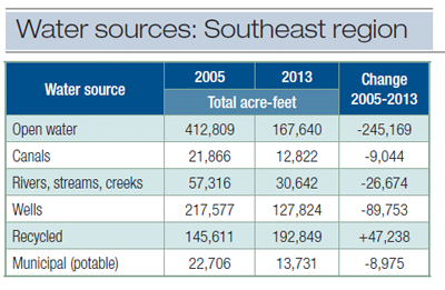
Table 8. Water sources used in the Southeast region.
Water costs
- In 2013, water costs for an 18-hole golf course were the second highest in the nation. Twenty-five percent of all 18-hole courses paid $60,300 or less per year for water, 50% paid $140,300 or less, and 75% paid $326,400 or less per year.
- In 2013, water cost per acre-foot had increased to $425, from $288 in 2005.
Water sources
- As in 2005, well water was the most commonly used water source in 2013 (Table 10).
- Between 2005 and 2013, use of all water sources decreased, with the exception of recycled water.
- The Southwest uses more recycled water than any other region
- Increased use of recycled water contributed to the 5.4% reduction in the use of potable water.
Transition region
From 2005 to 2013, water use across this region decreased by 25.4% (Table 11). Implementation of conservation efforts contributed approximately 83% to this decline. A large decrease in the number of golf facilities in the region (from 2,961 to 2,795) contributed another 17% to the water savings.
The region’s moderate temperatures, adequate rainfall and nine-month growing season allow facilities to irrigate fewer acres, with less water and for a smaller portion of the year compared with those in warmer, more arid climates (Figure 8).
Climate
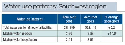
Table 9. Water use patterns in 2005 vs. 2013 in the Southwest region.
- Average temperatures in the Transition region are moderate, and vary only moderately across the region, from 47.2 F to 68.6 F.
- This region has highly variable average precipitation rates, ranging from only 2.0 feet to as high as 7.1 feet per year.
- Turf is actively growing nine months of the year in most locations in this region. There is little variation in the length of the growing season across the region.
Conservation practices
- In 2013, the percentage of golf courses using less water per acre than forecast by their water budgets (Table 11) had increased, indicating that water conservation efforts had a positive effect.
- The most common water conservation practices, listed in order of popularity, were using wetting agents, hand watering, keeping turf drier than in the past, increasing no-mow acreage, and adjusting fertilizer practices.
- In 2013, 20.6% of Transition region golf courses had reduced the number of irrigated acres. This is more than double the 7.9% from 2005 (Figure 2).
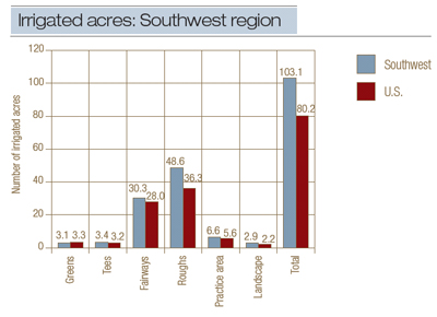
Figure 7. Median number of irrigated acres for an 18-hole golf course in the Southwest region vs. the U.S., 2013.
Water costs
- In 2013, water costs for an 18-hole golf course were moderate compared with other regions. Twenty-five percent of all 18-hole courses paid $4,900 or less per year for water, 50% paid $16,415 or less, and 75% paid $55,400 or less per year.
- In 2013, water cost per acre-foot had increased to $690, compared with $423 in 2005.
Water sources
- As in 2005, open water (lakes and ponds) was the most commonly used water source in 2013 (Table 12).
- Between 2005 and 2013, use of all water sources decreased, with the exception of recycled water.
Upper West/Mountain region
From 2005 to 2013, water use across this region decreased by 5.4%. Although this region reduced water use by all measures, decreases were not as dramatic as those seen in regions to the east, primarily because this was the only region where the number of golf facilities had increased (from 1,089 to 1,104) rather than decreased since 2005. This was offset by increased conservation measures, which led to reductions in acre-feet used per acre from 2005 to 2013 (Table 13).
Climate
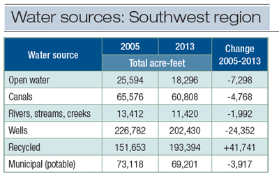
Table 10. Water sources used in the Southwest region.
- The Upper West/Mountain region is the largest of the agronomic regions in terms of area. Climates vary greatly, from the deserts of Nevada to the mountains of Colorado to the cold winters of North Dakota.
- Average temperatures in the Upper West/Mountain region are comparatively cool, ranging from 34.4 F to 64.6 F.
- Rainfall varies from quite low (0.4 feet/year) to moderate (4.9 feet/year).
- Because some of the areas of this diverse region receive little rainfall, many facilities must irrigate 100% of their turf acres (Figure 9).
Conservation practices
- In 2013, the percentage of golf courses using less water per acre than forecast by their water budgets (Table 13) had increased, indicating that water conservation efforts had a positive effect.
- The most common water conservation practices, listed in order of popularity, were using wetting agents, hand watering, keeping turf drier than in the past, using irrigation scheduling techniques, and adjusting fertilizer practices.
- In 2013, 22.0% of Upper West/Mountain region golf courses had reduced the number of irrigated acres. This is almost double the percentage (11.9%) from 2005 (Figure 2).
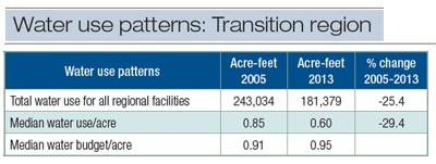
Table 11. Water use patterns in 2005 vs. 2013 in the Transition region.
Water costs
- In 2013, water costs for an 18-hole golf course were moderate compared with other regions. Twenty-five percent of all 18-hole courses paid $6,520 or less per year for water, 50% paid $20,430 or less, and 75% paid $64,100 or less per year.
- In 2013, water cost per acre-foot had increased to $199, compared with $151 in 2005.
Water sources
- As in 2005, well water was the most commonly used water source in 2013 (Table 14).
- Between 2005 and 2013, use of all water sources decreased, with the exception of well and municipal (potable) water.
Funding
The second phase of the Golf Course Environmental Profile was conducted by GCSAA through the Environmental Institute for Golf, and funded by the United States Golf Association.
Acknowledgments
The executive summary and the full public report of the results of the second phase (2005-2013) of the “Water Use and Conservation Practices on U.S. Golf Courses” survey are available online at www.gcsaa.org/Environment/Environmental-Profile/Golf-Course-Environmental-Profile-Overview.
Wendy Gelernter, Ph.D. (www.paceturf.org), and Larry Stowell, Ph.D., are the principals of PACE Turf LLC, San Diego.
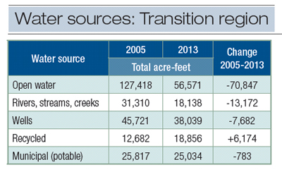
Table 12. Water sources used in the Transition region.
|
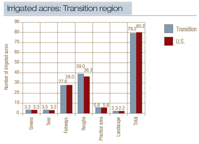
Figure 8. Median number of irrigated acres for an 18-hole golf course in the Transition region vs. the U.S., 2013.
|

Table 13. Water use patterns in 2005 vs. 2013 in the Upper West/Mountain region.
|
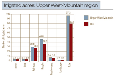
Figure 9. Median number of irrigated acres for an 18-hole golf course in the Upper West/Mountain region vs. the U.S., 2013.
|
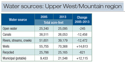
Table 14. Water sources used in the Upper West/Mountain region.
|
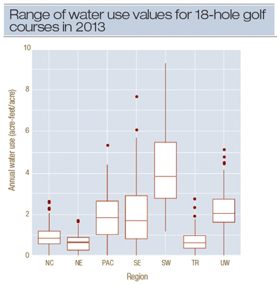
Figure 4. Range of water use values for 18-hole golf courses in 2013. The horizontal line in each box represents the median water use for each region, but the upper and lower vertical lines associated with each box represent the range of water use values reported by the majority of survey participants. The dots represent values that were outliers — single data points that were very different from the rest of the data set. Regions with the widest spread of water use values (Pacific, Southeast and Southwest) also had the most diverse climates. Abbreviations for regions: NC, North Central; NE, Northeast; PAC, Pacific; SE, Southeast; SW, Southwest; TR, Transition; UW, Upper West Mountain.
|