This region includes Connecticut, Maine, Massachusetts, New Hampshire, New Jersey, New York, Rhode Island, Vermont and Ontario
A former superintendent, Kevin also has an MBA from Southern New Hampshire University. He resides in Milford, N.H.
Tel. 800-472-7878, ext. 3635, Cell 816-807-3103; kdoyle@gcsaa.org
I don’t enjoy passing along difficult messages, not many do. This is especially true when it comes to regulatory issues. Alas, here we are facing an old foe yet again. Waters of The United States (WOTUS) is an item that GCSAA’s Government Affairs team and our Waters Advocacy Coalition have worked hard to both clarify and protect our industry against overreach. Below are a couple resources regarding the changes in regulations that became active on March 20, 2023.
The Government Affairs team dropped a blog update in December 2022 updating the membership on many details. The blog post can be found here: "Waters of the United States" (WOTUS) rule represents missed opportunity to clarify federal water regulation (gcsaa.org).
A short version is that the EPA is reverting to the extremely robust regulatory version during the Obama administration. Issues that would create harm to the golf industry revolve around “operations that are on, over or near potential waters of federal jurisdiction”, and “significant nexus.” With Federal jurisdiction reaching all the way to ephemeral streams, it becomes more unclear what areas of golf courses might be under federal jurisdiction. Add to it, deciding whether tributaries, wetlands, and other waters are under federal jurisdiction are near impossible for superintendents. With a misstep possibly leading to fines and worse, the implications of unclear regulatory items are critical to push back against.
WOTUS may not be allowed to stand: the Supreme Court is currently deciding a case – Sackett v. EPA – that could potentially overturn this rule. GCSAA has argued that the EPA and Corps should wait until the Sackett decision before publishing this rule, i.e. “no WOTUS before SCOTUS.” Until then, the rule is in place!
Have you researched the watersheds at your golf facility? Yes, you may have been on property for a very long time, seen droughts and extremely wet conditions. You may even be aware of those areas that are typically wet and impossible to mow or maintain during the early spring that dry out fairly quickly and are easily mowed during the season. Perhaps swales were designed to assist your golf course remove surface waters during peak rainfall. Well, the government may indeed classify those as waterways under the WOTUS rule.
Rather than dealing with the many frustrating issues within the WOTUS rule, I’m hoping you have utilized the mapping tool through the United States Geological Survey (USGS).
As described on their website, the USGS was created by an act of Congress in 1879, the USGS provides science for a changing world, which reflects and responds to society’s continuously evolving needs. As the science arm of the Department of the Interior, the USGS brings an array of earth, water, biological, and mapping data and expertise to bear in support of decision-making on environmental, resource, and public safety issues.
So while you may think you know your property best, what the USGS says about the surface water on your property is the only thing that matters! It may show wetlands where you may not realize, ephemeral streams where only dry swales exist, or connectivity between surface waters that are not evident.
This is the link to the USGS mapping site:
Water Resources of the United States—National Water Information System (NWIS) Mapper (usgs.gov)
It allows you to enter an address or site that will bring you to your facility. After putting in your address, click on “Map” then at the bottom of that window on the right, “Base Map.” For example, I chose a facility most of you would be aware of, Fairways of Halfmoon and added the maps that populate below.
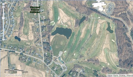
While you can see the ponds created on the property, and probably dry overflow spillways connecting those ponds if you zoom in, it appears those ponds are indeed separated. If they are man made for irrigation (I am unsure if that is the case), they would be exempt from the WOTUS rule if not connected to another waterbody.
By scrolling down and selecting “USGS National Map” in the base map options, the surface waters recognized by the USGS are developed, see below.
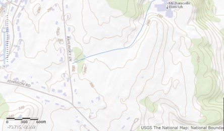
Of note here, the ponds aren’t even recognized, yet are deemed a stream (solid blue line). The forested area near Raylinsky Lane is surprisingly deemed a wetland (small water loving plants pictured). That connection of the ponds becomes a real problem as this map shows a “significant nexus” (remember that potentially hazardous phrase from above) across the Fairways property, all the way to Anthony Kill downstream (off the map above). So if Josh wanted to add cart path material to the area that passes across the overflow, or manage invasive weed species in or near that same overflow area he may need a federal permit. Change out the culvert pipe, federal permit. You see the issue for Fairways? If these waterways were deemed not to be WOTUS, then Josh would be dealing with the town, county, or state if needed. People with much greater knowledge of the property and understanding of the work to be done. No costly federal permit.
A few take-home messages for you. Take the opportunity to check out the map of your facility. Learn what the USGS deems the surface water at your facility to be. Understand how changes to WOTUS could affect the way you maintain your property, and advocate when given the chance!
Upcoming events in the region.